--- How Safe and Prepared Are We for the Big One?
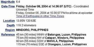
I was asleep hours ago when I was roused by a creepy feeling that woke me up and made me sense that an earthquake was occurring. I was even the one who told my soulmate to take cover. She was busy playing Icy Tower and was so engrosssed she hardly noticed the tremor. According to the US Geological Survey Earthquake Hazards Program website, which monitors near-realtime tremors around the world, this earthquake had the following details:
News from the radio said it was just around Intensity 3-4 in the Manila, Quezon City areas but I can swear it was stronger than the one I felt last September 16.
In times like these, there are only two things I pray for: one is that it wraps up immediately, and two is that it won't be strong enough to cause significant damage. For this one, so far, so good. The late night TV news said people were alarmed but there were no observable damages...yet. Let's hope it remains that way.
While we're at this, I got these spine-tingling facts about earthquakes from the US Geological Survey Earthquake Hazards Program website and a recent excellent article by Aubrey Sta. Cruz Makilan on the Metropolitan Manila Earthquake Impact Reduction Study or simply the MMEIRS project:
From what I've read and researched the Japanese-funded MMEIRS project was done to help the government FORMULATE A MASTER PLAN in case the BIG ONE happens.
- It is estimated that there are 500,000 detectable earthquakes in the world each year. 100,000 of those can be felt, and 100 of them cause damage.
- If a major earthquake were to hit Metro Manila today, the devastation would be so big even disaster response authorities cannot simply cope with it.
- Up to 35,000 residents of Metro Manila would die and up to 3 million others would need to be evacuated. In addition, some 175,000 buildings would be damaged. The pressure of collapsed buildings and the inability to rescue those who would be trapped inside would cause most of the deaths.
- The Metropolitan Manila Earthquake Impact Reduction Study or MMEIRS project, a Japanese-funded study that was begun in August 2002, cites "many research studies (indicating) that active phases of the (West) Valley Faults (formerly the Marikina Valley Faults) are approaching and that the estimated magnitude will be around 7 or more." But MMEIRS also raised the possible intensity from 7 to even 9, which could be "devastating."
- The MMEIRS objective was aimed to design a master plan for earthquake impact reduction in Metro Manila leading to the holding of training seminars on earthquake preparedness. Funded by the Japan International Cooperation Agency (JICA-Philippines), the study was supported by the Metropolitan Manila Development Authority (MMDA), the Department of Science and Technology (DoST), Phivolcs and JICA contractors Pacific Consultants International, Oyo Corporation, and Pasco Corporation.
- MMEIRS has identified the West Valley Fault, which lies just northeast of Manila, as "the fault expected to cause the largest impact in the metropolis." The West Valley Fault traverses Marikina town, Pasig going to Muntinlupa up to the south."
- The West Valley Fault, other studies showed, caused at least two major earthquakes within the last 1,400 years. No earthquake is known to have taken place along the West Valley Fault after the 16th century. But based on the estimated return period of less than 500 years, the Fault is due to exhibit dangers this century --- or even within the next few years, if the estimates of an official of the Philippine Institute of Volcanology and Seismology (Phivolcs) are valid.
- The MMEIRS project also found that aside from the estimated death toll, the West Valley Fault earthquake would cause injuries to 118,200 persons. The number of buildings expected to be destroyed by the Manila Trench earthquake would reach about 5,000 while 16,000 for the Manila Bay fault. The West Valley Fault earthquake will cause the collapse of buildings in northeastern Quezon City, western Marikina, eastern Pasig, Muntinlupa-Laguna Bay and Mandaluyong-Makati. Evacuation would be difficult in the metropolis' fringes particularly in the north, Taguig and Las Pinas.
- The deepest earthquakes typically occur at plate boundaries where the Earth's crust is being subducted into the Earth's mantle. These occur as deep as 750 km (400 miles) below the surface.
- The intensity of an earthquake is a measure of the shaking created by the earthquake, and this value does vary with location.
- The magnitude of an earthquake is a measured value of the earthquake size. The magnitude is the same no matter where you are, or how strong or weak the shaking was in various locations.
- The epicenter of an earthquake is the location directly above the hypocenter on the surface of the earth.
- The hypocenter of an earthquake is the location beneath the earth's surface where the rupture of the fault begins.
Do we have the MASTER PLAN in place now?
Or, with all the fiscal crisis and hunger problems haunting us now --- not that I'm belittling them --- are we simply unprepared and obliviously waiting for the pie to hit us in the face?
"Tsk, tsk...asa ka pa, you have too much faith in this government," was the hopeless reply my soulmate gave me.
I'm holding tight and bracing myself for the BIG ONE.
0 reactions:
Post a Comment